

Overview and context
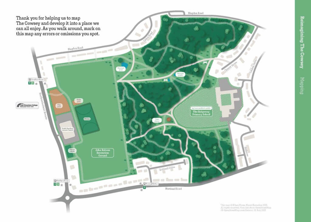
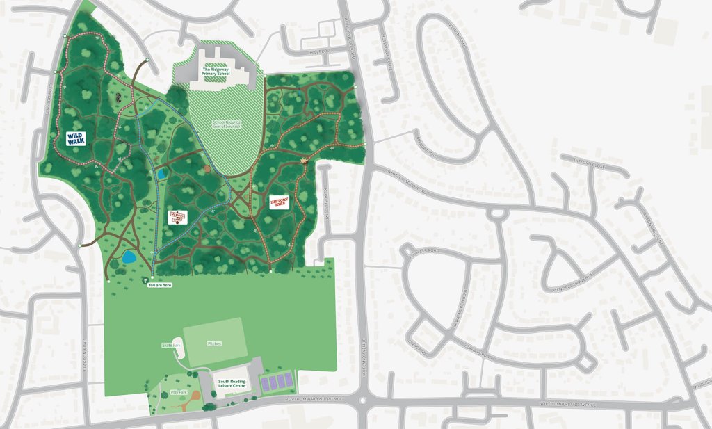
The Cowsey is a large (around 20 hectares) public site in the heart of Whitley, a neighbourhood in the south of Reading. It consists of a variety of unmarked trails in a mixture of both woodland and grassland. For this project, we were asked to develop a series of maps that could be used for large boards situated around the site, orientating users and showing the opportunity to interact with the green space around them. To engage with the local community, we joined Nature Nurture, a community interest company, with students from the New Directions College to evaluate and comment on proposals for the map; we further joined a research group from the University’s Department of English Language and Linguistics to hear of people’s opinions of using the Cowsey. Fully meeting the client’s expectations, we have now been approached by them to take on more mapping work in other areas in Reading.
Restated brief
Aim for the project
For this project, we wanted to improve how people experience and navigate through the Cowsey Woodlands area. This distinction between experience and navigation is interesting – whilst the woodlands require mapping for the basic navigation, we also wanted the experience of the woodlands to be one that created a sense of place and interest. By designing a welcoming and accessible wayfinding system, we help encourage exploration and develop the sense of place, helping visitors understand where they are but also where they could go.
Deliverables
Initially, the brief proposed a range of deliverables, including signage and a map of the green space. As the project developed, and the budget and scope were defined, the deliverables became more refined. The final deliverables evolved into three main outcomes:
- A detailed user-tested map of the Cowsey
- A framework for an external designer to use for ‘lecterns’, displaying a specific route available within the area
- Information boards to showcase the entire map at the entrances of the woodlands area
Timeline
Main points in the timeline of this project included:
- Thursday 22nd May
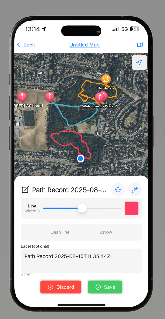
- We visited and mapped the core paths of and around the Cowsey area using Strava so that we could start digitising almost immediately. (see Mapping)
- Thursday 29th May
- We joined Nature Nurture and Sylvia Jawoska in a focus group to involve and ask the community for feedback on the area. (see Research)
- Wednesday 11th July
- We participated in an event alongside students from New Directions College to get feedback on our draft map. Their feedback was astonishingly useful and guided most future developments. (see Research and Mapping)
- Monday 14th July
- We revisited the Cowsey after feedback to plot all the paths that were missing as a result of feedback from the students and staff of the New Directions College. (see Research and Mapping)
- Friday 15th August
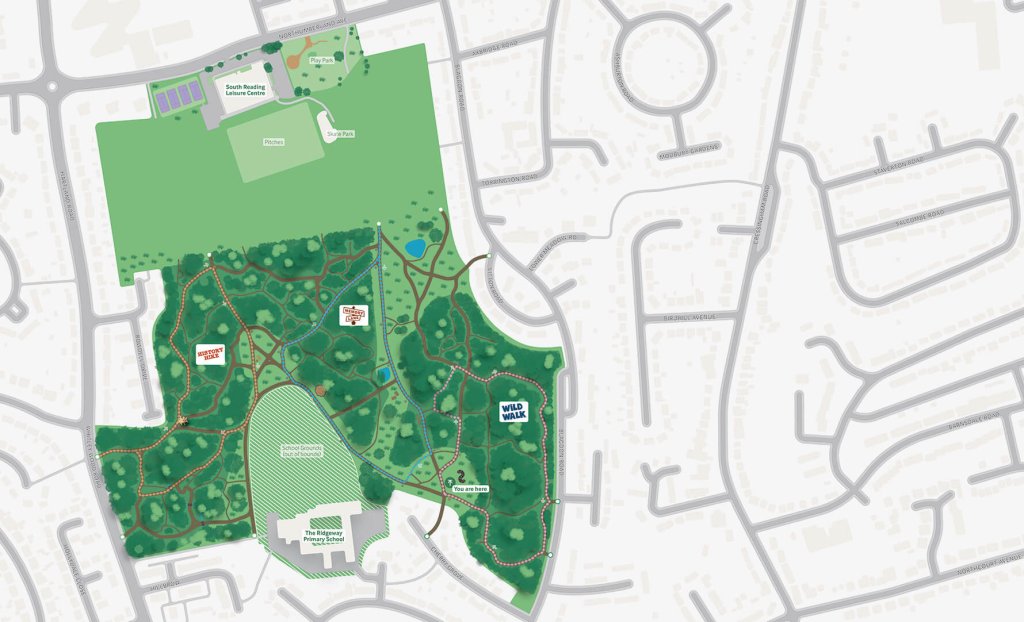
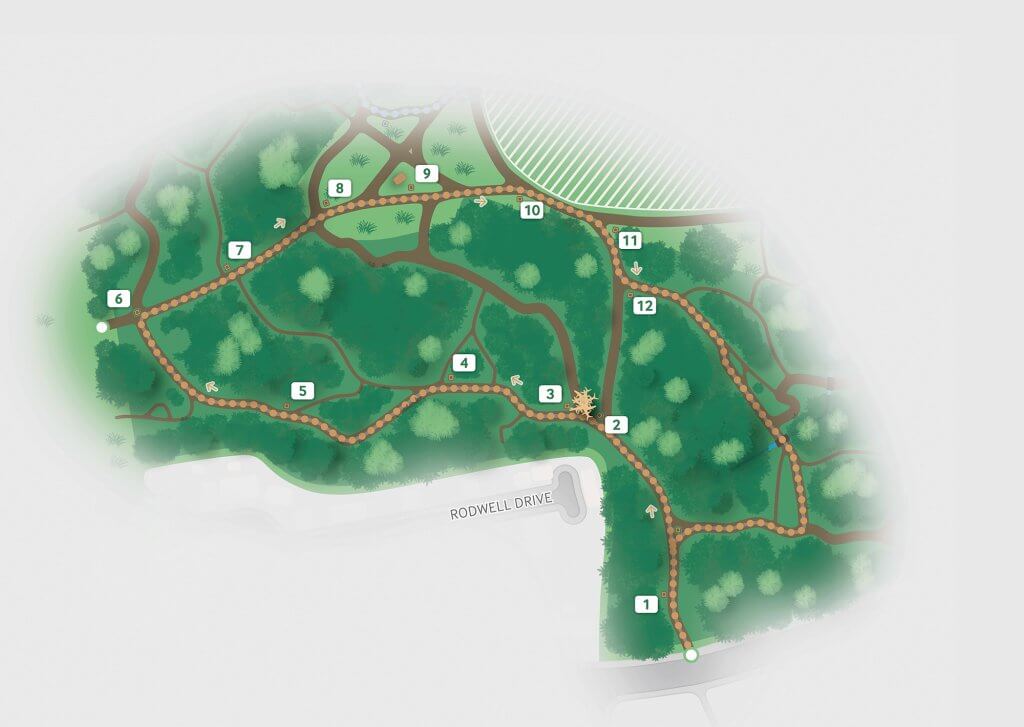
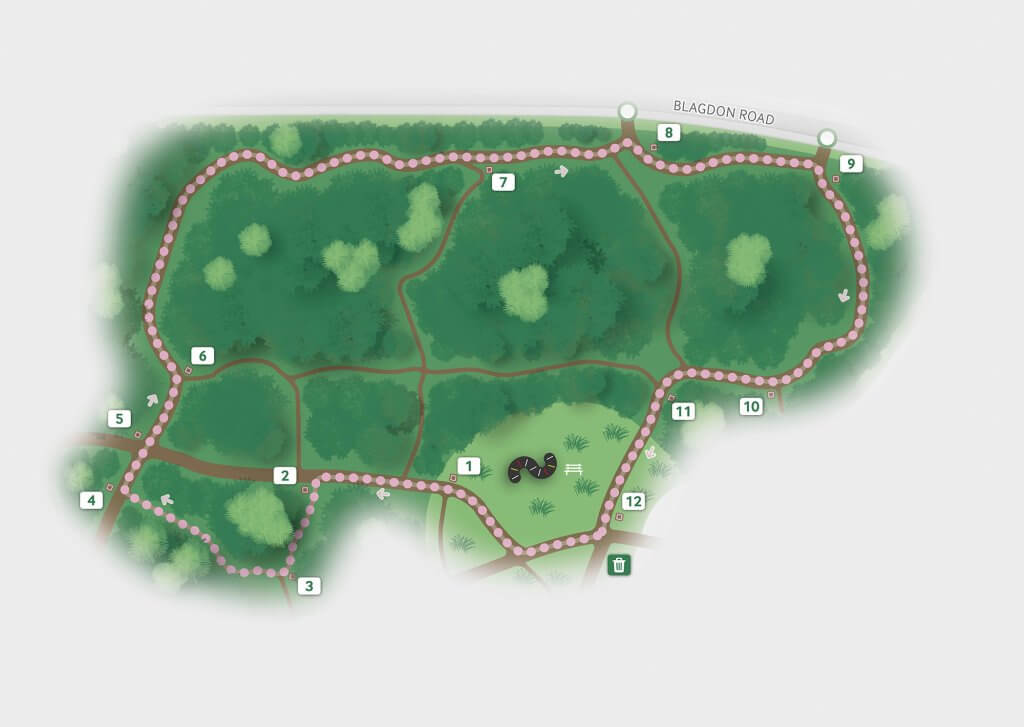
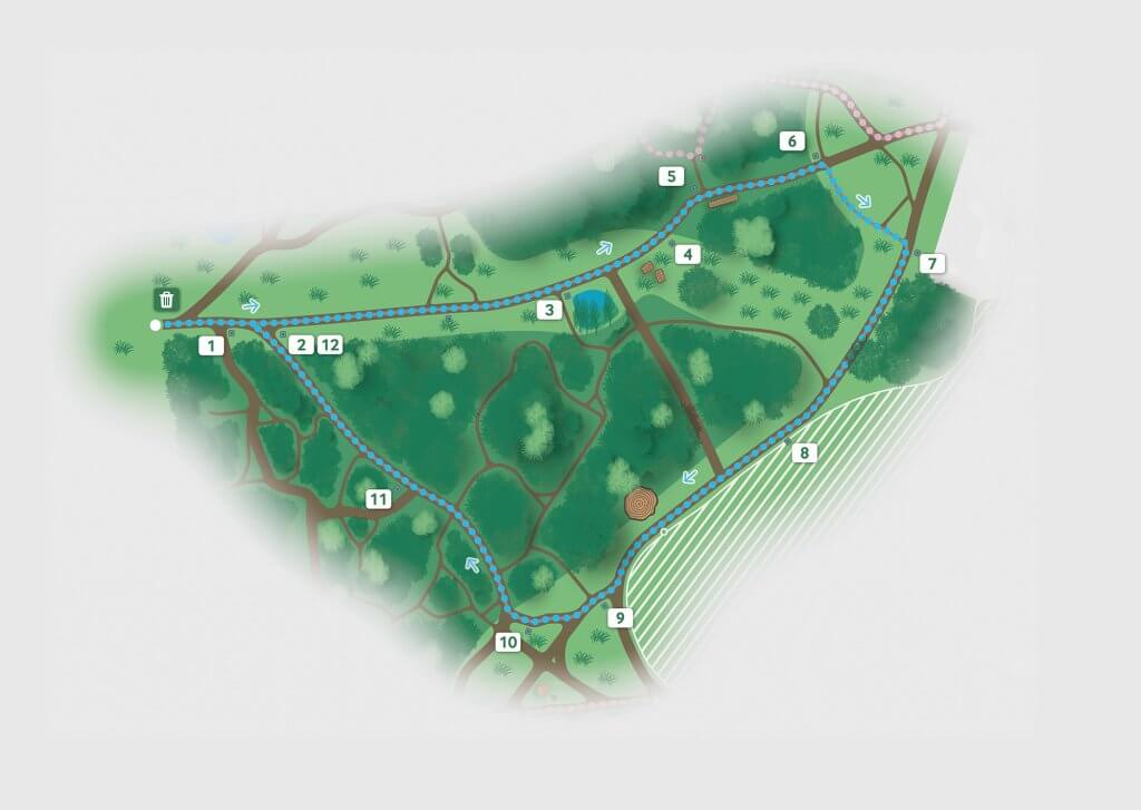
- We revisited the site once again to plot the three trails that appear on the map – the ‘Wild Walk’, ‘History Hike’ and ‘Memory Lane’
Mapping
Mapping the area was a brand new skill to both of us and we relished the challenge of learning new software and adapting our skillset to develop a strong outcome. We started off by sketching the map physically and using Strava to plot our course, specifying that any path that appeared clear and large enough would feature on the map. Initially this was effective at showing the routes we thought were necessary.
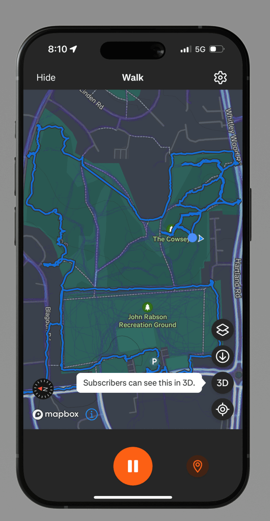
Following on from our engagement with the New Directions College, whose campus is situated close to the woodland site, we received extensive feedback that the paths were drawn incorrectly. Part of the reason that we drew them ‘incorrectly’ was because we had, at some points, excessively smoothed the paths to the point that they no longer resembled the paths which physically existed. The main issue, however, was that the criteria that we selected the paths (in retrospect, ‘clear’ and ‘large’ are poor criteria) with was completely unclear to the end user, leading them to suggest – quite understandably – that they had been given a map that was unrepresentative of the site. This directly led us to the conclusion that all navigatable paths should be shown, even if they lead to dead ends (which ought to be noted graphically). To map them this time, we used actual GIS data from an app called MapCanvas.
Research
The research phase of our project was illuminating. As documented by the research project conducted by Sylvia Jawoska, a general consensus that the Cowsey was ‘unsafe’ and ‘unwelcoming’ was advanced by many participants, citing illicit drug use, confusing pathways, and few features to create a sense of place; for example, in later research, we concluded that there existed only two benches in the whole area. Whilst constructing benches for this project was not our responsibility, wayfinding improves the sense of place immeasurably, and we were satisfied that the development of a map would be beneficial to the community.
Development
- Addition of minor paths
- Following feedback from New Directions College students, minor and secondary paths were added to the map to ensure accuracy and reduce confusion while walking along the routes.
- Expanding the map
- The map had to be extended to fit the scale of the information boards which led to increase in number of roads and buildings.
- Map reorientation
- The map was reorientated to align with the visitor’s position on side, making it easier to understand the direction in which they will start their walk.
Delivering the maps
Delivering the maps to the client proved to be another exercise in packaging files correctly, which we again seized upon. The client required three ‘focussed’ maps (i.e. maps documenting the walks) and two maps showing the whole area, differentiated by their orientation.
We had designed the maps in such a way that they could be resized freely right up to sendoff. This enabled us to use the same core files in multiple different environments; the focussed maps for the three separate walks, for example, use the same underlying file with a simple blur to focus the user’s attention.
The extraordinary weight of the files (with a wide variety of effects, shadows and lines) led to difficulties being experienced with exports, with some exports taking over 5 minutes at a time. To prevent this from affecting the external designer, we rasterised the file such that the effects were ‘flattened’. This meant that we could rapidly deliver iterations to the client.
Reflection
This project was a valuable real-world design experience. Engaging with Nature Nurture and members of the local community throughout helped to ensure that outcomes met everyone’s needs. One of the most rewarding aspects was seeing how user feedback directly influenced the final design decisions.
This project also had some challenges, particularly around accuracy and making the map simple enough for the users to understand without excluding any details. It required multiple iterations and back and forth refinement with the client to provide the best possible outcome.
Overall, this project strengthened our confidence in working with real clients, responding to feedback, and designing for public spaces. The skills gained from this project will directly inform all our future design work including a further freelance relationship with Nature Nurture to redesign further places in reading with the same style as our Cowsey map.